
How Do We Measure Plate Movement?
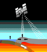
Well, scientists now use satellite and laser technology to measure the movements of the plates. How? Well, the laser pulses are shot from the ground to the GPS satellite showing the exact place of where the plates are! The Western Canada Deformation Array or the (WCDA) is a permanent GPS Tracker Network from the Geological Survey of Canada. The array is especially made for the North American and the
Juan de Fuca plates.
